
New online tool helps truck drivers plot route
Thursday, January 15, 2015
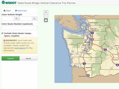 |
A new online tool allows truck drivers to more easily research bridge heights – and potential conflicts – before they hit the road. The Washington State Department of Transportation was already updating its bridge clearance information at the time of the May 2013 Skagit River Bridge collapse. The bridge collapsed when an oversize commercial truck struck and damaged the upper bridge supports causing a section of Interstate 5 and two vehicles to fall in the river. The newly collected bridge data became a springboard to develop the state route bridge vertical clearance trip planner as part of WSDOT’s overall response to the collapse. “This innovation offers truckers a new tool to find the safest route for their trip,” said Gov. Jay Inslee. “It applies lessons learned from the Skagit River Bridge replacement, and it will reduce the risk of collisions throughout the system.” Using GIS mapping, the trip planner shows drivers which bridges on their proposed route should be avoided or approached with caution because heights may vary by lane. While the ultimate responsibility for checking clearance levels remains with the truck driver, this tool makes it easier to fulfill that obligation when applying for trip permits. The trip planner database will be available to third-party developers who have expressed interest in creating navigation apps. This open data approach allows the private sector to use state-generated data to develop even more tools to improve highway and motorist safety. “We’ve taken advantage of existing technology to help improve safety on our roads,” said Transportation Secretary Lynn Peterson. “Sharing this data through private-public partnerships will help get this information into even more customers’ hands.” The trip planner was developed in consultation with the Washington Trucking Association, whose members conducted beta testing on the tool. In addition to the new tool, WSDOT also has clarified its commercial vehicle policies, initiated a statewide review of all signing for low-clearance structures, added the bridge clearance list to its road restrictions webpage and added a step-by-step guide to help drivers determine what type of permit they should request. All bridges with a minimum clearance of 16-foot, 6-inches and lower also will be re-measured as part of a comprehensive statewide review scheduled for completion in late 2015. WSDOT also will continue to expand the trip planner features, including displaying lane-by-lane height information. That work will be completed by 2017.
“This is a huge step in the right direction,” said Sheri Call, the association’s vice president of government of relations, noting drivers previously had to look up bridge data online or in a book and then consult their own maps.